Monday, September 27, 2021

A Good Day for Trade


A couple of weekends ago, consort and I headed over to Trade, Tennessee, for the second annual Trade Mill and Native Heritage festival.  The event is held on the grounds of the Trade community center where the old trade mill is located.  The grounds are the original location of a trading post established in the early 1700s by Daniel Boone.  The Trade Gap trading post was established for Native Americans, pioneers, and fur traders to come together to buy and sell their wares.  This natural mountain gap, an old buffalo trail between Snake and Rich mountain, was the easiest route through the mountains to the west  and connected the Great Warrior Path through the Shenandoah Valley and Tennessee Valley to Piedmont, North Carolina.  Trade is known as the oldest community in Tennessee with English-speakers arriving as early as 1673.  


Trade's claim to fame is the story of Tom Dula who was made famous by the song Tom Dooley (Dula is pronounced Dooley in the local dialect).  The song is a North Carolina folk song based on the 1866 murder of a woman named Laura Foster in Wilkes County, North Carolina.  After allegedly committing the nefarious act, Tom Dula took off from North Carolina and eventually arrived in Trade, Tennessee, where he went into hiding.  It was in Trade that the posse finally caught up to Dula and arrested him.  He was taken back to North Carolina where he was tried, convicted, and ultimately hanged for the murder of Laura Foster.  


The story of Tom Dula and Laura Foster is intriguing.  The two knew each other as children and grew up playing together.  His true love was Anne Foster, Laura's cousin.  As the story goes, Tom and Anne were intimate at a very young age, but the affair was ended when Anne's mother found the two in bed together.  A couple of years passed and then Tom enlisted and served in the Confederate Army.

I'll skip over Tom's military career, although it is fairly interesting.

After the war, Tom returned home and renewed his relationship with Anne while at the same time beginning a relationship with Laura, Anne's cousin.  Folklore has it that when Laura became pregnant, she and Tom decided to elope.  The morning she and Tom were to take off together, Laura left her home early in the morning on horseback and was never seen again.

No one really knows what happened that day, but local speculation is that Anne killed Laura in a fit of jealousy when she found out Laura was pregnant.  Anne was the one who led authorities to where Laura was buried.  At the trial, another cousin of Anne's, Pauline, testified that Anne had previously taken her to Laura's gravesite to ensure it was still well hidden.

Witnesses at the trial testified they heard Tom Dula make the incriminating statement that he was going to "do in" the one who gave him the "pock" (syphilis).   The testimony suggested that Dula believed Laura had given him syphilis which he then passed on to Anne.  However, the local doctor testified he had treated both Dula and Anne for syphilis, as well as Pauline Foster who, in fact, was the first to be treated.  Many believe that Dula caught the disease from Pauline then passed it on to both Anne and Laura ~Wikipedia.

This is a 1927 Ingraham Viceroy pocket watch.  The vendor has fashioned it into a necklace.
I couldn't resist.  It now belongs to me.  I'm not sure I'll ever wear it as a necklace; it seems a bit too large.
In my stays-in-one-place home I had four wind-up, chiming clocks.
When we took off in the fifth wheel, all of the clocks found a new home with my daughter.
This little pocket watch fills the void with its very loud ticking and need for winding.

When Tom arrived in Trade, he introduced himself as Tom Hall and took a job working a farm belonging to Colonel James Grayson.  Grayson is also mentioned in the song, Tom Dooley, which started the myth that Grayson was Tom's rival for the affections of Laura Foster.  The truth is that Grayson had no previous connection with either Dula or Foster.  Once Dula's true identity became known, Grayson was instrumental in his capture and arrest by the posse from Wilkes County, North Carolina.

Maybe it's just me, but I thought this was a great story!


It was a beautiful sunny day when we arrived at the Trade Days festival, but after only an hour or so, it began to rain.  Consort and I took shelter, with D.O.G., under a large tree.  While waiting out the rain, the above pictured little girl happened along and asked if she could pet our dog.  She was very friendly and outgoing.  Her name is Jada and she is ten years old.  She is a member of the Cherokee Tribe.  The boots she is wearing were originally made by her great-great grandmother for her great-grandmother.

I asked her if she had been dancing that morning.  She said that, in fact, she had just finished participating in the rain dance.  I said, Well, it certainly seems to have worked!  Do you know how to do any "make the sun shine" dances?  She said, Yeah, I believe I do.  She then began to do her sunshine dance.  Believe it or not, within ten minutes of her finishing her dance, the sun came out and we were once again blessed with a beautiful sunny day!

Tuesday, September 21, 2021

The Channels of Virginia


One day last week, we and our friends here at Roan Creek decided to go for a hike.  The destination, The Channels of Virginia.  The Channels Natural Area Preserve is located north of Abingdon, Virginia, and just south of Saltville, Virginia, a two-hour drive from our campsite.  To actually reach the Channels, one must hike to the top of Middle Knob on Clinch Mountain.  The 5,000 acre preserve is managed by the Virginia Department of Forestry and was opened for public use ten years ago.  Not many people, including the locals, are aware of its existence.

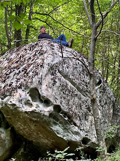
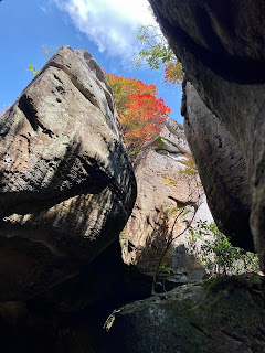
The Channels are a maze of 400-million-year-old sandstone blocks with crevices 30-40 feet deep.  Some of the crevices are just large enough for an adult to walk through.  Geologists believe that the change from blocks into separate boulders, outcroppings, and crevices occurred during the last ice age.  Permafrost and ice wedging led to freezing and expanding which eventually resulted in the only slot canyon on the East Coast.


There are two hiking trails leading into the Channels; one is rated moderate and the other is rated easy.  After some discussion, we all decided to take the short, easy trail which is a six-mile hike out-and-back with a gain of around 1,000 feet in elevation.  After checking directions on several different GPS apps, we were satisfied with our route and headed out for our adventure.  

When we left the main road outside of Hayters Gap, Virginia, we turned onto a one-lane, switchback gravel road that led us four miles farther into the woods and up the mountain.  None of us were sure we were on the right road, but we kept on in good faith until the road was blocked by a gate.  Beyond the gate was an old lumber road which we assumed would lead us to the Channels.  We parked the truck, donned our backpacks, grabbed our hiking sticks, and set out in search of our target.


About halfway through our journey up the mountain (and having encountered no other hiker), we determined we were not on the short, easy hike.  We're still not sure how it happened, but we ended up on the moderate, 11-mile hike.  In the 5.5-mile hike up the mountain, we gained 2,600 feet in elevation.  According to Fitbit, that's 130 flights of stairs.  For those of you who follow this blog regularly, you'll remember the difficulty I had climbing 330 feet on the mountain across the road from our campsite.  Both consort and I agreed the constant climb upwards for 5.5 miles should be rated DIFFICULT as opposed to moderate.


The four of us range in age from 60 to 67.  Between the four of us we have a bad hip, a bum knee, a damaged shoulder, and a weak back.  However, there was one in our group who skipped happily along the trail ahead of us all and encouraged we three stragglers to stay the course.  From a distance of 100 to 200 yards ahead (and above) us, he would holler back, You've got to see this view, or, C'mon! You've made it this far, you can make it the rest of the way! 


We did not see any signs along the trail that let us know where we were or how many more miles we must hike to reach the summit.  The trail itself was clearly marked with red slashes painted on trees, and there was one sign indicating when we actually entered the nature preserve.  I knew from reading about the Channels that when we reached the top of Middle Knob, we would find a retired fire tower.  The lookout tower was built by Franklin Roosevelt's Civilian Conservation Corps in 1939, retired in 1970.  I also knew, based on my research, that the descent into the Channels was considered steep and treacherous.  Let me just say here that none of us found the descent into the canyon to be difficult.  After 5.5 miles of climbing, we were just happy to be going downhill.


Towards the top of the mountain, the trail switched back and forth in an attempt, I suppose, to make the trail less steep.  At one point, one of us in our group declared, quite snarkily I might add, that he could go no farther.  Our cheerful guide suggested we three take a break while he hastily hiked the trail ahead to see what he could see.  We rested for only ten minutes before we heard our boss guide calling happily to us that we were just one, maybe two football fields from reaching the top.  After a quick assessment of our screaming muscles and shortness of breath, we took a vote and decided to soldier on.


The Channels were worth every uphill step we took.


Once we arrived in the Channels, we saw quite a few other hikers.  They had all taken the short, easy hike -- although they did say it was a very steep climb over a short distance.  The hikers we talked to were astounded to learn we had taken the L.O.N.G. route up the mountain.

All in all, there are 20 acres of channels that can be explored from down below within the slots, or from above if you're willing and able to hop from boulder to boulder.  Without any discussion, we opted for ground level exploration.  If you were to wander very far into the depths of the Channels, you would need a very good sense of direction to find your way out again.  It was mid-afternoon when we finally reached the Channels, and still had a 5.5-mile hike to get off the mountain, so we did not explore as far as we would have liked.  That's unfortunate.  Because try as I might, I cannot get any member of our motley ensemble to agree to a second hike to the Channels.


Quote of the day:  Girl, every time we get together we make some kinda memory!