Friday, July 17, 2020

Biking


Earlier this week, on a beautiful sunny day, consort and I drove to Damascus, Virginia, to ride the Virginia Creeper Trail.  We rented bikes and were then shuttled, along with nine others, to the summit of Whitetop Mountain where we were dropped off at the trailhead.  The shuttle ride from Damascus to the peak of Whitetop Mountain is 17 miles which translates into 40 minutes of driving time.


The trail was moderately populated.  Most of the cyclists were families with little kids, although there were four quasi teenagers who zipped past us going down the mountain, then passed us again as they came back up the mountain, only to pass us yet again as they headed down the mountain.  When an opportunity presented itself, I hollered out to one of the kids as they flew past, Hey, didn't you already pass us once, to which he replied, We have to keep waiting for our parents.  

The ride itself was very easy with lots of coasting involved.  I was surprised at the end to find we only averaged about eight miles an hour over the course of the ride.  We made lots of stops for pictures and to examine the local flora and fauna.  There were rhododendron thickets throughout the woods and we also found a hedge of blackberry canes alongside the trail.  The top photo showcases a beaver's lodge we spotted.  The entire ride was very peaceful, serene even, with only the sounds of birds chirruping in the woods and the creek running over smooth stones for a soundtrack.

I could post hundreds of pictures of the vertical scenery here in Northeastern Tennessee.  It is a lush verdant forest with creeks and rivers throughout.  Our friends were recently in Belize and tell us what we are seeing here is very like the tropical rain forest they recently visited.  To avoid the risk of  overwhelming you with photos of scenery -- which never does it justice -- I'll just post a few of my favorites.

Once we finished our ride and turned in our bikes, we decided to drive about five miles south of Damascus to see the Backbone Rock Tunnel pictured below.  It is also known as the World's Shortest Highway Tunnel.  The tunnel is 75 feet high, but only a few feet wide.  The tunnel was made in 1901 by blasting a hole through the massive rock to accommodate a rail bed, then a lumber road, and now a highway.  The photo on the left is the south entrance; the photo on the right is the north entrance.


Tuesday, July 14, 2020

Northeastern Tennessee

I give it three stars.


This delicate periwinkle flower, chicory, grows wild along the roadsides on tall, thin stems.  It is a beauty and it is ubiquitous.  Chicory, however, is also grown commercially.  The roots are baked and ground, then can be used as a coffee substitute or an additive to coffee.  Coffee made with chicory is more common in the southern states than the northern.  The largest producer of chicory in the United States is in Nebraska.


The Sunflower Festival in Mountain City, Tennessee.
Yes!
Festivals are still occurring in Northeastern Tennessee, but on a much smaller scale.


Sycamore Shoals Historic State Park

Elizabethton, Tennessee

In 1772, the leaders of the settlement around Sycamore Shoals came together to establish, "the first free and independent community on the continent," four years prior to the signing of the Declaration of Independence.

In 1780, Sycamore Shoals was the muster site of the Overmountain Men.  The Overmountain Men were frontiersmen from west of the Appalachian Mountains who took part in the Revolutionary War.  These Tennesseans were rebels even back then.  King George III had declared it unlawful for anyone to live west of the Appalachian Mountains.

The park features a 1.2 mile hiking trail on the south bank of the Watauga River.


These two pictures are of the Carter Mansion and family cemetery.  John Carter was one of the primary leaders of the settlement in 1772.  He and his son, Landon, who served in the Revolutionary War at the age of 16, built their home between 1775 and 1780 three miles from Sycamore Shoals.  This structure is the oldest standing frame house in Tennessee.  The county where this house and cemetery are located was named after the Carter family in 1796.  The town of Elizabethton was named for Landon's wife, Elizabeth.
This is the path we hiked.  Notice how level it is.  There was NO climbing involved.

Bella just being Bella


These two trees are examples of trail-marker trees.  Native Americans and frontiersmen intentionally shaped trees to point out trails and streams, and to indicate where items have been buried.  A distinct characteristic of the trail-marker tree is a horizontal bend several feet off the ground making it visible from great distances and even in snow.  Consort and I found a shovel and have done some digging.  We've not found any buried treasures... yet.
Fly fishing.  Sycamore Shoals is on the south bank of the Watauga River.  On the north bank is an RV park.

Shout out to Canada, although this is a Sycamore Maple and not a Red Maple.


Additional Notes:


I have learned to make scones! 

I am both charmed and captivated by colored glass.  I absolutely love finding sea glass.  Sea glass is weathered glass found on beaches along bodies of salt water.  The weathering process produces naturally frosted glass.  Sea glass takes 20 to 40 years, sometimes as long as 100 years, to acquire its characteristic texture and shape.

Living in Oklahoma doesn't provide much opportunity to pick up sea glass.  When I lived in Broken Arrow, each day I would take the dogs for a long walk.  While the dogs were occupied sniffing, I was picking up what I fondly refer to as gutter glass.  Gutter glass would be the bits of broken glass one finds littered in parking lots and along the curb in the gutter.  Think what you will, but I always felt I was performing a community service by picking up the sharp, broken glass while all the time pursuing my favorite hobby of collecting colored glass.  

The photo above shows the glass I've found on the beach of the creek.  Beach glass comes from fresh water and has a less frosted appearance than sea glass.  Note the piece of purple beach glass.  That color is a very rare find!

Each night as I go to sleep, I am treated to a myriad of fireflies that I can see from the window beside my bed.  It is an extraordinary show of exceptional beauty.  (The photo is not my own.  Try as I might, I could not get a useable picture.  This picture is from a news article alerting Tenneesseeans to the arrival of hundreds of fireflies in the Smoky Mountains.  The Firefly Festival was, of course, cancelled.)

I've started rereading Cold Mountain by Charles Frazier, a native North Carolinian.  The actual Cold Mountain is about 3.5 hours south of where we're parked.  Sadly, we will not be able to work in a visit to Cold Mountain this year.  However, reading the book Cold Mountain while parked in the Appalachian Mountains has brought all that I am seeing down to a more personal level.  It has given a voice, although fictional, to the monuments and historical sites we have viewed.


This is how I imagined it would be and I am so very grateful.  ~Mrs. M, The Magpie Flies

Monday, July 13, 2020

Saturday, July 4, 2020

Hiking Cove Mountain

Laurel Falls, Hampton, Tennessee


A couple of days ago, consort and I decided to hike to Laurel Falls with the three mangy mongrels.  Laurel Falls is an 80-foot high waterfall outside of Hampton, Tennessee, about 45 minutes from our campsite.  (Everything is about 45 minutes from our campsite.)  It is named for the flowering shrub, Mountain Laurel, which grows along the trail and near the falls.  The trail itself is a part of the Appalachian Trail.  Roundtrip, the hike to the falls is 2.6 miles.  It was an easy trail to follow and well maintained.  The dogs were on retractable leashes and thoroughly enjoyed themselves.  Consort and I also enjoyed the hike.  It has been some time since we have done any real hiking, but our lack of participation did not seem to be a deterrent.


We encountered a dozen or so other hikers returning from the falls as we were heading out.  Each of the hikers looked as if they'd had a pretty hard day of hiking.  We had casual question-and-answer convos with the hikers we met up with and were told the stair climb was the hardest part of the hike, but the falls were worth the effort.  Consort and I continued on down the trail holding fast to our lifelong mantra of,  How bad can it be?  

Six-and-a-half years ago, my friend and I hiked this same trail to Laurel Falls when I came to Tennessee for a visit.  Aside from the beauty of the falls, I didn't remember much about the hike, you know, whether or not it was difficult, making me think it must not have been that hard.  The main thing I remember about that hike was that I "fell off the mountain," at least that's how my friend puts it.  She and I stepped off a narrow path at some point to allow other hikers to pass us by.  When I stepped backward, I lost my footing and began rolling down the mountain.  I eventually was stopped by a large tree I landed against.  When I opened my eyes and looked up the mountain, I saw a rather large boulder coming straight for me.  Luckily, it was stopped in the fork of a small scrub-type tree just above where I came to a halt and before it landed on my head.

Consort and I crossed the footbridge you see pictured and came to our first set of stairs.  The stairs are large, flat rocks that have been set into the mountain to aid hikers.  Over time, and with weather, the ground changes causing the rocks to shift and move the stairs.  But if these were the stairs that everyone was talking about being so difficult, we were going to be okay.  It was pretty easy going.

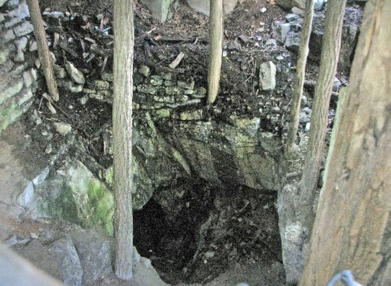
We walked perhaps another half mile when we came to the actual stairs referenced by hikers.


This is a picture of the stairs that lead down to the basin of the falls.  To reach the basin, you follow these stairs down a 250-foot drop in elevation.  It was a little tricky navigating the jumbled stones, especially with dogs in tow.  (The closeup of Bella is from the larger picture.  She kind of blends in with the stones.)


     About halfway down the path to the plunge pool, consort and I stopped to catch our breath.  I distinctly remember saying to consort that although I was willing to hike to the bottom of the trail, we  need to be aware that we will have to climb back up the stairs to get ourselves out.  To which he replied:  How bad can it be?


Here's a note from me to you:
It can be bad.
It can be very bad.

We got to the bottom of the trail and sat down to enjoy the scenery and catch our breath.  The dogs were not the least bit winded and set about sniffing everything within reach.  

Consort and I did not discuss the climb back to the top.  In fact, we actively avoided the discussion.  

We did notice an alternate route out of the basin once we got to the bottom of the stairs that looked pretty flat.  When we were ready to climb out of the basin, we discussed whether we should try the alternate route.  Not knowing where the route came out was a problem.  How to get back to the parked truck from wherever the route ended was another problem.  If we could have been certain of cell phone signal, I think we would have taken the flat route, regardless of outcome, and then called our friends to come get us.  Not knowing whether we would have a working cell phone led us to the conclusion we had to climb the stairs.

I will leave out the whining and near tears that ensued on the climb up the stairs.  Honestly, I didn't complain too much, and I did not cry at all, but only because I didn't have the breath to do so.  Consort had hold of all three of the mangy mongrels.  Bella and D.O.G. were hopping step to step without any problem -- although D.O.G. did sit waiting on each step for me to climb up before he jumped to the next step.  Annie is twice as old as the other two dogs and not nearly as agile.  Several times consort had to lift her from one stair to the next, but overall, she really was quite the trooper.

So here we are, the five of us, climbing the mountain.  Consort has control of two dogs with one hand, while lifting and helping Annie with the other.  Me, I grabbed onto his belt to help me climb.  He is my Rock of Gibraltar.

As soon as we climbed up the 350-foot elevation gain, I collapsed in a heap by the side of the trail.  As I sat beside the trail, a jumble of quivering muscles with a heartrate of nearly 200 -- I could not breath and I felt faint, but I mustered the strength to check my heartrate on Fitbit -- I was hit with a wave of nausea.  It wasn't long before I began retching; dry heaves that shook me to the very core of my being.

I wasn't paying much attention to anything that was going on around me during all of this, although I was aware of a young family that caught up with us during the climb.  I was trying very hard to be modestly unobtrusive, which is not an easy task when you are collapsed by the side of a hiking trail and vomiting into the bushes.  I remember hearing the dad of the family group warning his children to stay away from me and to keep their distance.


I guess it's just bad luck when you take your family out for a nice quiet hike in the woods -- a place you can go and avoid those potentially infected with CV-19 and all the while maintain social distancing -- and you run across a *beyond-middle-age* lady collapsed on the side of the trail, puking.  

The first picture is me when I reached the top of the climb and the dry heaves had subsided.  The second picture is once I recovered.

After all the physical exertion, we decided to have dinner out.  We headed for Elizabethton and some barbeque from Big Dan's BBQ.   I wasn't able to eat anything, but consort enjoyed every bite.  And, so, the day ended well.

Author's note:  Enjoy the pics of the falls.  We may never attempt another hike.  It's two days later and my legs still feel like wet noodles!


A perfect day

And they're beginning to stack up


Yesterday was the first sunny day we've had in weeks.  The five of us spent the day outside enjoying the quintessential summer day.  Bella kept an eye on the ducks.  Annie stood in the cold water, lost in thought.  D.O.G. sat faithfully at my side.  Consort and I spent the day enjoying adult kool-aid and reading.  Our friends joined us later in the day for dinner.  I hope your day is as pleasurable as ours!


Abingdon, Virginia

June 27, 2020


White's Mill and Mercantile.  It is 3.5 miles outside of Abingdon, Virginia, about a 45-minute drive from our campsite.  The Independence Sparks loaned consort and I a book called,  Off the Beaten Path.  It lists out-of-the-way places to visit; attractions that are not so packed with tourists.  White's Mill in Abingdon was featured in the book.  The drive to Abingdon was beautiful, and we enjoyed seeing the old mill, which is still in use today.  We were completely entertained by our conversation with the proprietor of the Mercantile.


The trailhead for the Virginia Creeper Trail begins in Abingdon and runs through Damascus, Virginia.  We have not yet done the bike ride from the top of Whitetop Mountain to Damascus due to stormy weather.

Today is a very sunny day, but we've had three solid weeks of rain showers, and the forecast is for rain every day next week.  The rain doesn't slow us down, we all have raingear -- including the mangy mongrels, but the novelty of a rainy day has worn off.  A bike ride in the rain can be slippery, and is never pleasant; consort and I are holding out for a dry, sunny day.

With all the rain, the creek has been very high.  Here's Bella watching the ducks, waiting for them to get closer.  And there's D.O.G. checking out the rapids.  He's sporting his new super-short haircut -- which we all love!!


We stopped by two additional places in Abingdon.  The first was a cave just off Main Street where, allegedly, the wolves who attacked and killed Daniel Boone's dogs lived.


We also stopped at the local cemetery.  If you're a regular reader of this blog, you'll know I am a taphophile, a person interested in cemeteries and gravestones.  I love reading the epitaphs; they can be thought-provoking and give you a small glimpse into an individual's life.  Each cemetery tells the story of a time, a place, and the people who lived and died there.  We find it fascinating!

I love that it says, All Burials Must be Pre-Authorized

This mound houses the grave of a Confederate general

You could not read many of the gravestones.  They are very weather-worn after nearly 250 years.

Friday, June 26, 2020

Shorts

Repel Insect Repellent, Sportsmen Max with Deet.  It's my new go-to hairspray this summer in the mountains of Tennessee.  Works well as a backup perfume, too.

On the agenda for today was a hike to Laurel Falls just off the Appalachian Trail.  As we headed out the door, I happened to glance down at the footwear consort had chosen for hiking.  Loafers.  That's when I realized I really am married to a city boy.

A vintage 1973 Volkswagen Bug spotted on the side of the road.  I miss my buggy!!


This is Pal's Sudden Service where you can get a hot dog or burger, fries and a shake.  I love their signage.  Consort and I had a dog covered with old-fashioned drugstore chili.  It was quite tasty!
Life here, at least for us, has been slower.  I think if I stayed long enough I might finally unwind!